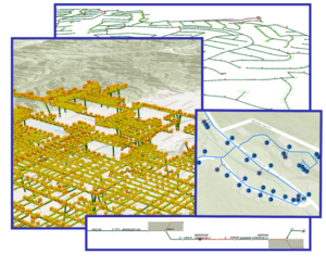
Santa Clarita Valley Water Agency (SCV Water) has revolutionized its asset management by integrating Esri’s ArcGIS technology to unify both linear and vertical assets. This strategic move has streamlined operations, enhanced data accuracy, and fostered seamless collaboration across departments.
Key Highlights:
- Unified Framework: By adopting Esri’s ArcGIS Utility Network, SCV Water established a cohesive system to manage distribution networks alongside facilities like pump stations and wells.
- Innovative GEAR Solution: The development of the GIS-enabled Asset Registry (GEAR) provides non-GIS professionals with an intuitive, web-based platform to manage vertical assets effectively.
- Enhanced Visualization: Leveraging 3D capabilities, staff can now interact with assets across over 90 pump stations, more than 60 tank sites, and over 50 wells, with plans to integrate SCADA data in the future.
- Operational Efficiency: This integration has improved data access, strengthened quality assurance, and serves as a powerful training tool, laying a robust foundation for a fully integrated, GIS-centric asset management system.
Kudos to SCV Water and partners like DCSE for pioneering a unified approach to asset management, setting a benchmark for utilities aiming to enhance efficiency and data integration!
You can read the full story here on the Esri Industry blog for Water Utilities here: A Unified Approach to Asset Management: Transforming SCV Water’s Management of Linear and Vertical Assets


Have any thoughts and/or comments on this post? Feel free to share by posting below.
LOCATION
DCSE Inc.
23461 S. Pointe Drive
Suite 300
Laguna Hills, CA 92653
CONTACT
CALL (949) 465-3400
FAX (949) 586-8141
0 Comments